A look back at the Flood of '64. The water just rose and rose
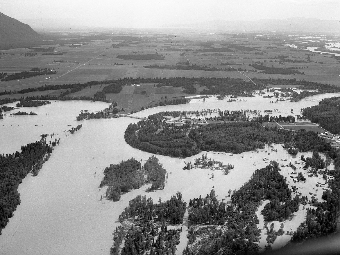
An aerial view of flood waters in Columbia Falls, June 9, 1964. The lower bridge is Highway 2, the upper bridge is the Red Bridge in Columbia Falls. The entire Mosquito Flats neighborhood is under water (lower right) as is much of South Nucleus Avenue. Perhaps most interesting is the flooding east of the bridge. (Hungry Horse News archives)
By WILLIAM SPENCE
Note: The following story was done on the 50th anniversary of the flood. Some minor edits and additions have been made.
Fifty-eight years ago the waters rose and rose until they became the largest flood in Flathead County’s recorded history.
When torrential rains poured on top of a heavy mountain snowpack on June 8-9 of 1964, it caused, by some measures, one of the most powerful flash floods in the United States.
Water poured down both sides of the Continental Divide, tearing out roadways and rail lines and ripping away bridges. Three dams failed. Another was over-topped. At least 28 people died and more than 2,200 homes and buildings were damaged or destroyed in seven counties and a dozen communities in Montana.
Nothing remotely like it had happened before, ever since white settlers first moved into the Flathead in the mid-1800s.
As of May 1, gauges across Northwest Montana were registering snow depths as much as 75 percent above average.
Four days later, after storms dumped up to 13 inches of snow across the western half of the state, it was already the second-snowiest May on record, with more snow in the forecast. At least two new record lows were set during the month, and it wasn’t until just before Memorial Day weekend that the high temperatures broke 70 degrees.
On May 7, National Weather Service climatologist Richard Dightman issued the following caution: “We aren’t in trouble unless we get a sudden warming and the snowpack melts all at once. However, we don’t look for that to happen — very rarely does snowmelt by itself cause flooding. But if we get rain on top of it ... then we’re in trouble.”
The warning received little attention.
IT STARTED RAINING Sunday afternoon, June 7.
It wasn’t too bad down in the valley — a half-inch or so out by the airport.
But in the mountains it was a deluge: Essex got 11 inches in 30 hours; Marias Pass on the Continental Divide got 15.5 inches by Monday night.
Climatologists later determined that three storm systems had collided over the Northern Rockies. Storms from the east and northeast ouds from the south to produce a 37-hour torrent of rain — warm rain that cut through the deep, wet snowpack like a hot iron.
Quiet streams turned into boiling cauldrons. On Bear Creek, just west of the Continental Divide, the water scoured slopes down to bedrock, stripping them clear of trees, picking up massive boulders and tearing away part of the highway as well as huge stretches of land under railroad tracks.
At 5:25 a.m. June 8, just east of Essex, the Middle Fork washed out a 200-foot section of the Great Northern railroad line (now BNSF Railway). It took out the U.S. 2 bridge shortly thereafter, cutting off all ground transportation across the Divide.
Then it bore down on Nyack.
“THE THING I remember is the noise, this great roar,” said longtime Nyack rancher John Dalimata, who was 22 at the time. “It was terrifying.”
Dalimata’s home is about 30 miles west of the Divide and a half-mile south of the river. It’s also south of the high-way and the railroad tracks, which split the valley east to west.
“We have 200 acres of hay meadow north of the tracks,” he said. “The week before, we’d moved our cattle over there, including about 100 yearling calves. We weren’t much worried about flooding. We’d had floods before, in ’48 and ’54, but they hadn’t done much damage. In an emergency, we just moved the cattle across the tracks to a Forest Service meadow we leased.”
But this time there was no warning, no indication of an impending disaster.
“The first I knew about it was when a big gush of water came out of the creek behind our house,” Dalimata said. “I jumped on a Cat (bulldozer) and started working in the creek, trying to keep it out of the wood pile. Then I dropped that and helped my dad try to get the cattle out. But we didn’t even come close. The water came up too fast.”
They lost 192 head, including the yearlings.
EAST OF THE DIVIDE, the destruction was even greater.
Communities from Cut Bank to Great Falls experienced flood damage. Dams failed at Lower Two Medicine Lake and East Glacier. West of Dupuyer, Swift Dam failed as well, sending a 30-foot wall of water racing down Birch Creek.
At least 28 people drowned.
West of Great Falls, there were reports that Gibson Dam had failed, spilling 99,000 acre-feet of water into the Sun River Valley. A Forest Service pilot sent to investigate discovered a three-foot wall of water coming over the top — 66,000 cubic feet per second, according to the Bureau of Reclamation.
But the dam held. People in West Glacier and Columbia Falls were unprepared for what was coming. Radio reports advised them that the river would crest at 15.5 feet — 1.5 feet above flood stage, but 4 feet less than the ’48 flood.
“We drove up to West Glacier on Monday morning and there were people standing out on the bridge watching the river,” recalled Katherine Lundstrom, whose husband, Darvin, was Columbia Falls police chief.
“Darvin’s mother and I and our daughter walked out there and could feel the whole thing shaking,” she said. “Darvin ran out and told us to get off, because he thought the bridge was going to go. After we came home, he changed clothes and left and I didn’t see him again for two days.”
DARVIN AND SCORES of other volunteers and professionals across the valley pitched in to help families evacuate. When the water got too high, they drove boats through the churning river to rescue people from rooftops and other high ground.
And the ground had to be much higher than anyone ever expected: The Flathead River level at Columbia Falls hit 15.5 feet at 4 p.m. Then it hit 18 feet at 8 p.m. and was climbing a foot per hour.
The river finally crested Tuesday morning at 26 feet. Peak flows were an unheard of 176,000 cubic feet per second.
The floodwaters spared little in the vicinity of the river.
More than 20 miles of U.S. 2 were damaged or destroyed along with miles and miles of Great Northern track. A section of Blankenship Bridge collapsed Monday night and the Going-to-the-Sun Road bridge at West Glacier buckled. The eastern half of the Old Red Bridge in Columbia Falls also washed away, together with three homes; another 50 homes south and east of town were flooded.
The Belton Bridge at West Glacier, just upstream, was heavily damaged. But the arch survived. It would be quickly rebuilt with a deck and would become the West Entrance to the park until the main bridge could be replaced.
“The water kept rising until it reached the bottom of ‘Dead’ on the Dead End sign on south Nucleus Avenue,” noted the Hungry Horse News at the time.
Mel Ruder of the Hungry Horse News later won the Pulitzer Prize for his one-man, nonstop coverage of the 1964 flood.
Evergreen was particularly hard-hit as Flathead Lake essentially backed up all the way to the town.
Flathead County Commissioner Clifford Haines flew over the flood and described it in an interview: “It’s a solid river, three to four mile wide in many places. Many houses in the northern end of the valley aren’t just under water. They’re gone, completely washed away.”
Thousands of animals and whole forests washed away, too, clogging the river and Flathead Lake.
Flathead County officials recovered about 1,200 dead animals — but not a single drowned horse. Most of the victims were cattle, pigs and pets. Three barge loads of dead animals were collected from Flathead Lake.
Cleanup would take months and rebuilding neighborhoods took years. The Mosquito Flats neighborhood in Columbia Falls is still adding homes to this day.